
Etna: Earthquakes and tectonic faults
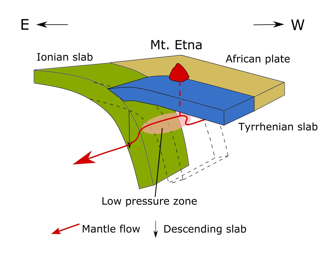 Etna in Sicily is one of the most active volcanoes in Europe. Its existence is directly related to the complex tectonic situation of the region. Etna is located in the area of influence of several large and small earth plates, whose borders run not far from the volcano. The volcano is located in the area of the fault zones directly associated with the collision of Africa and Europe. In the western part of Etna, there is also the border to the Ionic Plate, which is subducted under the Calabrian Plate. Along these superordinate fault zones strong earthquakes can occur, which have often led to catastrophes in Sicily.
The sketch on the left shows the plate tectonic situation on Etna. However, an unusual representation was chosen, since the sketch is oriented towards the south. This means that above is south and below is north.
Regional fault zones on Mount Etna
etna-bannerEtna itself is crossed by numerous regional tectonic fault zones. The largest structures are the Northeast Rift and the Pernicana fault zone in the north of the volcano. To the east is the Timpe fault zone, which is composed of several smaller faults. On one of these faults the earthquake of Christmas 2018 occurred, in the southeast there is the Trecastagni-Tremestieri fault and in the south there is the South Rift. In the southwest is the Ragalna fault and further west the west rift manifests itself. In October 2018, an earthquake of magnitude 4.7 occurred along the Ragalna fault, causing damage to buildings in the town of Santa Maria di Licodia.Earthquakes on Etna
 With all these fault zones, it is not surprising that there are also tectonic earthquakes on Etna. But even these are often related to magma movements under the volcano. This is because they create stress in Etna, which can trigger earthquakes in the fault zones.
Most of the earthquakes on Etna are of low magnitude, but there are always some with magnitudes up to 4.9. Especially when the hypocenter is at a low depth, these earthquakes can cause damage to the aged building fabric.
In historical times, such earthquakes occurred for example in 1865, 1875, 1907 and 1984, but from the more recent past the earthquakes of 27 October 2002 and 26 December 2018 are worth mentioning. Both earthquakes were related to rapid magma rise (inflation) and flank eruptions. While the eruption of 2002 lasted several weeks, the one of 2018 was a short flash in the pan of a few hours. The earthquake of 1865 occurred after an eruption when there was a phase of deflation.
Sliding of the Etna eastern flank
The fault zones and earthquakes are not only related to the eruptions, but also to the deposition of the eastern slope. This moves downwards towards the sea at a rate of 3-5 cm per year. The movement has recently been demonstrated under water. The slow sliding of the eastern slope can accelerate in eruptive times: During the 2001 flank eruption, the slope subsided by roughly 2 m. But the researchers suspect that not only magma movements under the volcano are responsible for the sliding of the eastern flank, but also gravity. If a landslide does indeed occur, a catastrophic tsunami threatens the Mediterranean Sea.Sources: INGV, Italy, the cradle of volcanism, Wikipedia
Picture sources Figure 1: wikipedia, FieldsetJ after Gvirtzman, Z., & Nur, A. (1999) Picture 2: Antonio Scaltrito via researchgate.